Here it is again, the pattern we do not like to see in early spring. A significant Arctic cold outbreak is underway in Eastern Europe and is forecast to bring freezing mornings in the coming days, including snow in some areas. Thanks to remnants of the collapsed Polar Vortex aloft, the Arctic blast will significantly freeze to blossoming fruit trees across central and eastern Europe and the Balkan peninsula.
After a recent warm period and well-above-normal temperatures in March 2025, a significant change in the general weather pattern over Europe is coming up. A powerful Arctic cold blast will spread across eastern Europe, including the Balkan peninsula, part of the Mediterranean, and Turkey.
As we enter the second week of April, temperatures have already become warmer, and vegetation stages have started in many parts of Europe, including the blossoming fruit trees. Therefore, these late-season cold air mass outbreaks are hazardous for this vulnerable vegetation.
Very low morning and night temperatures often cause significant damage to flowering fruit trees and other vegetation. They become susceptible to temperatures just a few degrees below freezing, especially in their early growing stages. With this Arctic blast, temperatures in some regions could push well below -5 °C.
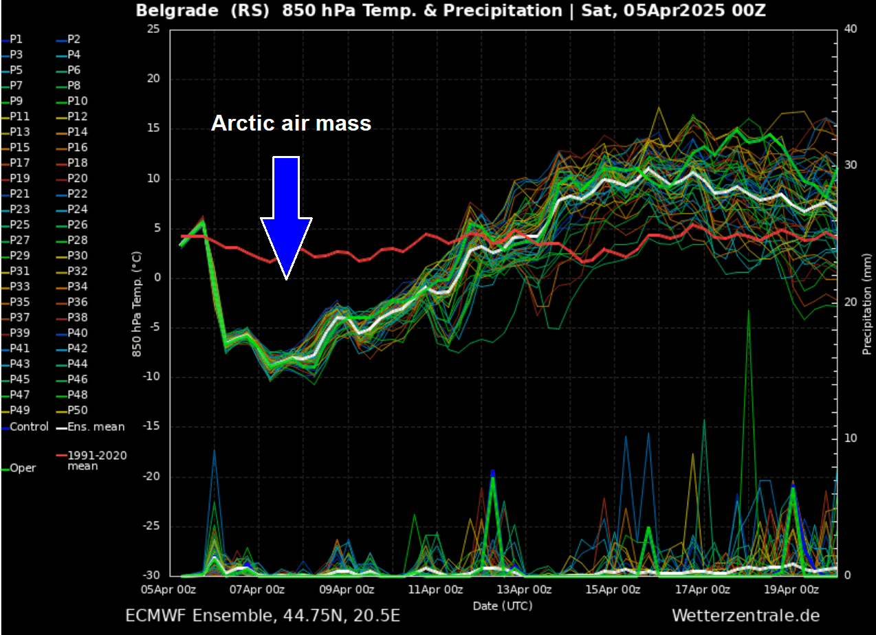
The meteorogram chart below is for Belgrade, Serbia, which will be near the core of the cold pool in the coming days. The temperatures will drop significantly below normal, to around 15 °C below the average. The freezing period will last until next weekend.
Interestingly and sadly, this year will not be an exception regarding potentially damaging frost. Over the last few years, most of the Aprils since 2015 have resulted in damaging, locally even destructive frost due to extreme cold mornings. The most recent widespread and significantly damaging event was in April 2021.
Again, these cold events come this year after the too-early warmer periods in March. So nature’s vegetation blooming is fast underway.
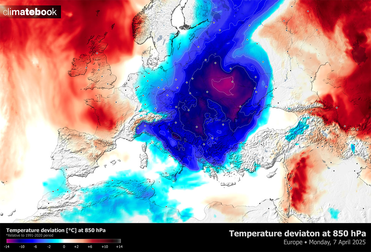
Below is a quick animation overview of the upcoming Arctic cold blast into Eastern Europe. It starts over Scandinavia and Russia and spreads into eastern Europe on Sunday. The cold reaches the Alps, the Balkan peninsula, and most of the Mediterranean by Monday and persists throughout the week. As we can see, a very dramatic temperature change/anomaly will develop.
After the substantial disruption of the polar vortex and the shift of patterns across North America, one of the cold pools shifted towards western Russia and Europe early this month, moving far south in the coming days. Now, let’s look into the day-to-day details of how this cold event evolves. It appears likely that a high potential for damaging frost for many will develop.
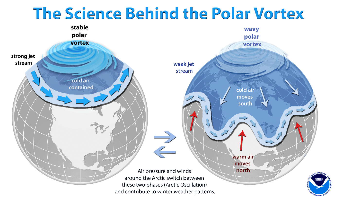
Before we discuss the details of the upcoming event, we want to consider the main trigger behind these cold events. The intense Arctic blasts often follow a substantial disruption of the Polar Vortex aloft. This disruption may be temporary during the winter, or the events may follow when the polar vortex finally collapses in early spring.
What is the Polar Vortex?
The Earth’s atmosphere has six layers around the planet. Most of the dynamics for our daily weather occur in the lowest two layers, known as the troposphere and the stratosphere.
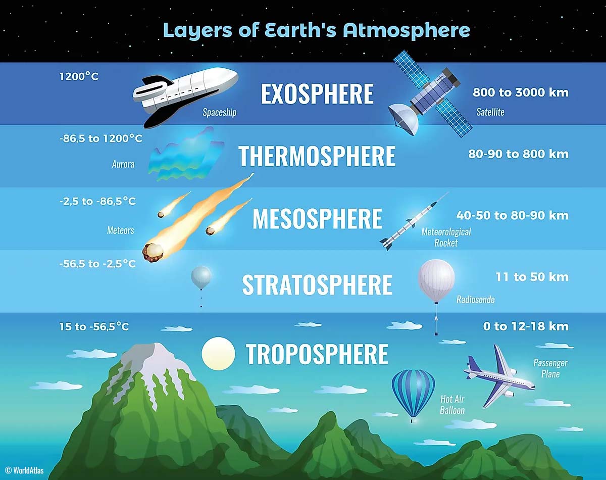
The troposphere is the closest layer to the Earth’s surface. It is about 12 km deep and extends from the ground up high into the sky. Depending on where you live, its depth varies from around 8 km to almost 20 km. The troposphere is the deepest above the equatorial region and gets much thinner above the North and South poles.
Above this layer is a much deeper one known as the Stratosphere, an 11-50 km thick layer of arid air. The stratosphere also contains the ozone layer, which protects our planet’s life against the potential impact of solar storms from the Sun or outer space.
Another essential feature in the stratosphere, which makes our weather even more variable, often triggers significantly large-scale and long-lasting winter weather events. This is the Polar Vortex—an enormous, tri-dimensional ring of powerful winds moving through the sky above us. The Polar Vortex is spinning around the North Pole, grazing through the air at about 20-50 km above the Earth’s surface with violent wind speeds.
The troposphere and stratosphere are crucial for our climate. The Polar Vortex covers most of the bottom half of the atmosphere. Since the vortex extends from the middle of Earth’s troposphere into the stratosphere layer, it significantly affects winter weather across high and mid-latitudes yearly.
In recent years, we have experienced this in Asia, Canada, the U.S., and Europe. The vortex aloft has been significantly disrupted, and when its lobe shifts on the other side of the northern hemisphere, the extreme cold grips the North American continent.
Soon after winter, sudden stratospheric warming often occurs, resulting in a significant disruption of the Polar Vortex. Its large-scale weather pattern shifts further south across the northern hemisphere, posing the risk of early spring cold outbreaks and damaging frosts to blossoming trees and crops.
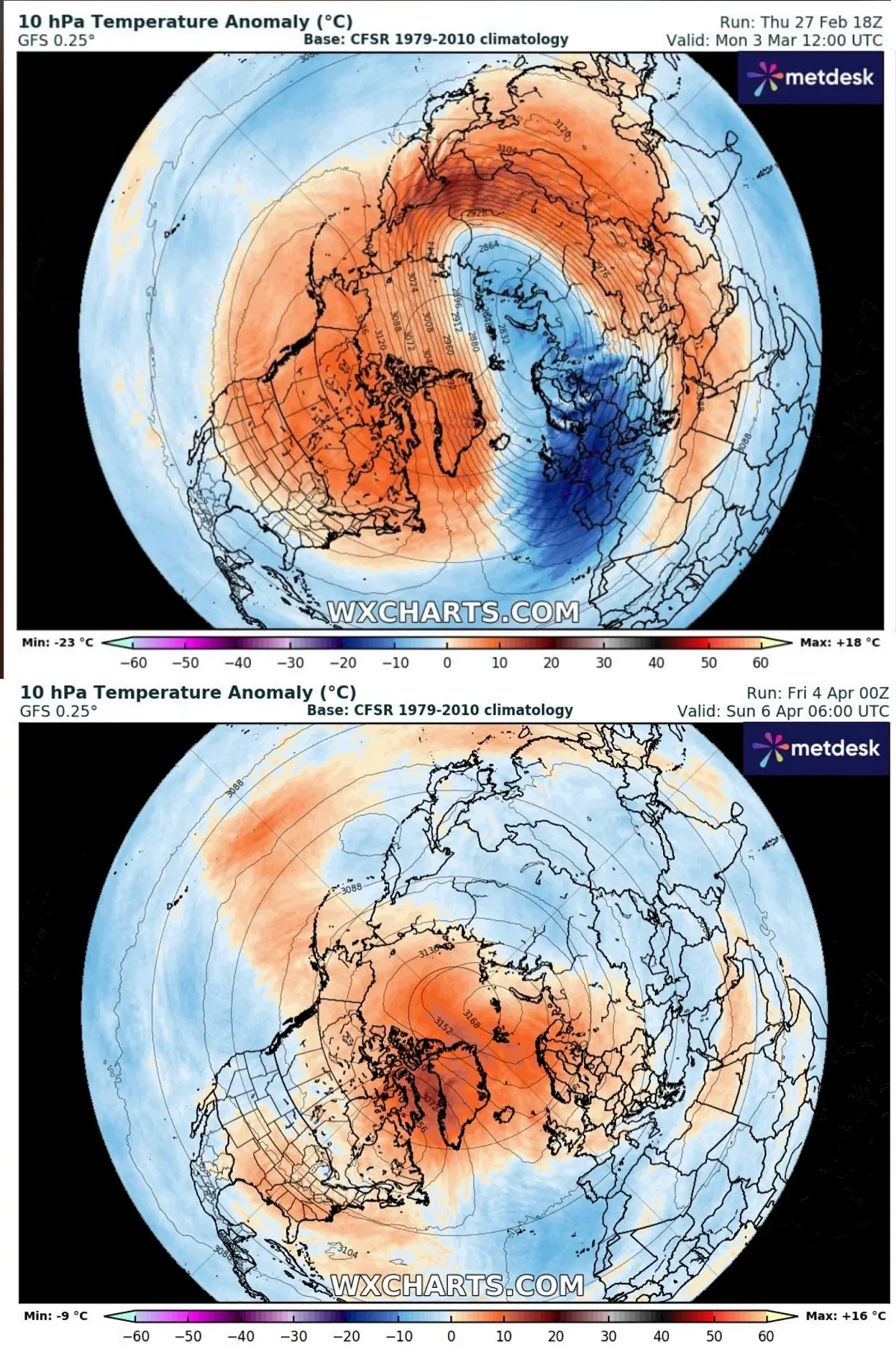
The comparison chart above shows the state of the polar vortex in early March compared to next week. We can see a disrupted circulation, with warmer air over the North Pole while the cold has shifted away far towards the South.
A cold outbreak is rapidly progressing from Scandinavia and Russia towards the south
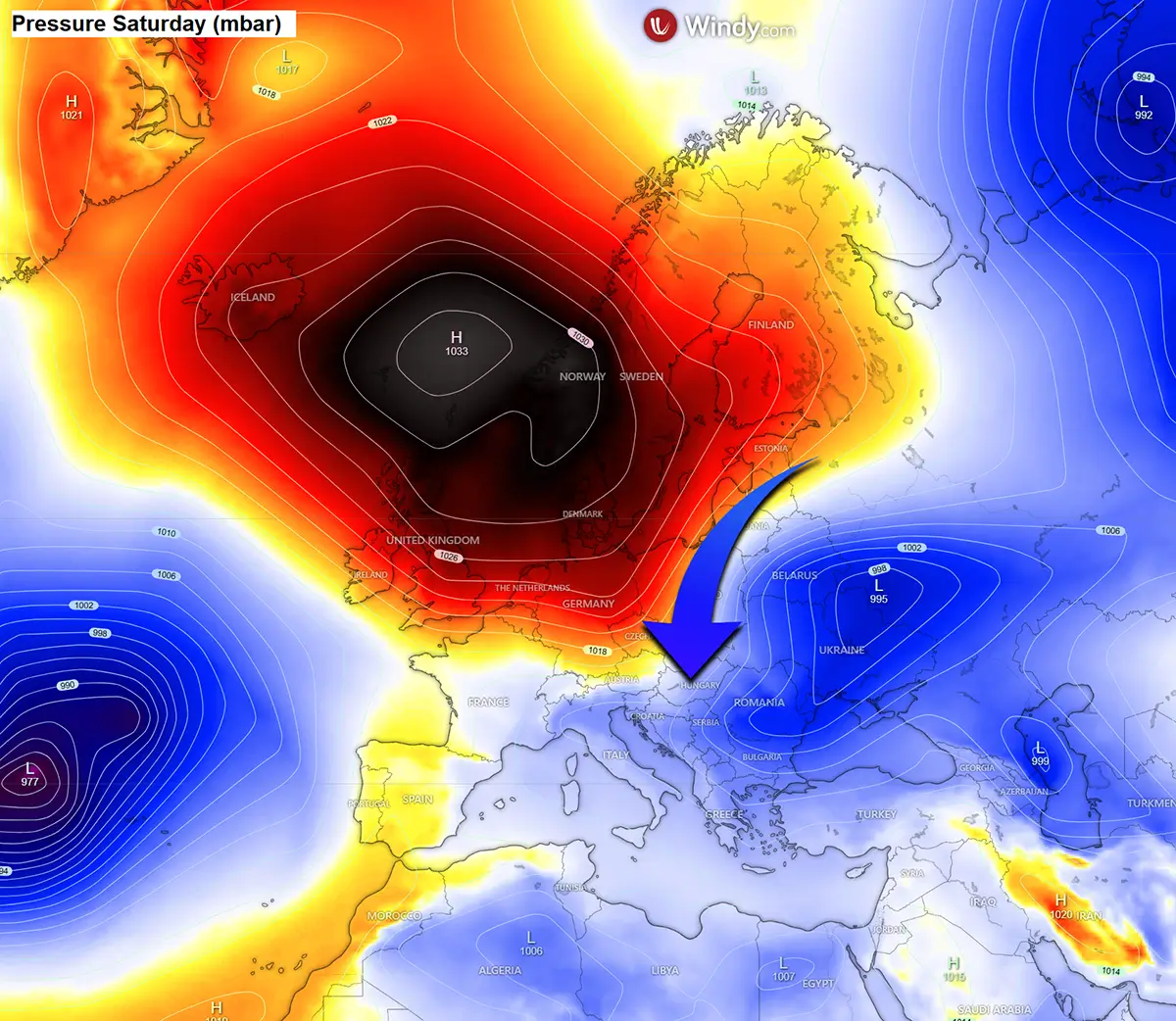
This weekend, the changing pattern is underway, with strong blocking building up on the west and a deep cold wave over Russia and Scandinavia. On Saturday afternoon, the airmass satellite image revealed an extensive frontal system low moving south across the Baltic region, Belarus, and Poland into Ukraine and towards the northern Balkans.
A significantly colder air mass is visible rounding the core of the low, which is spreading across Poland and the Baltic Sea.
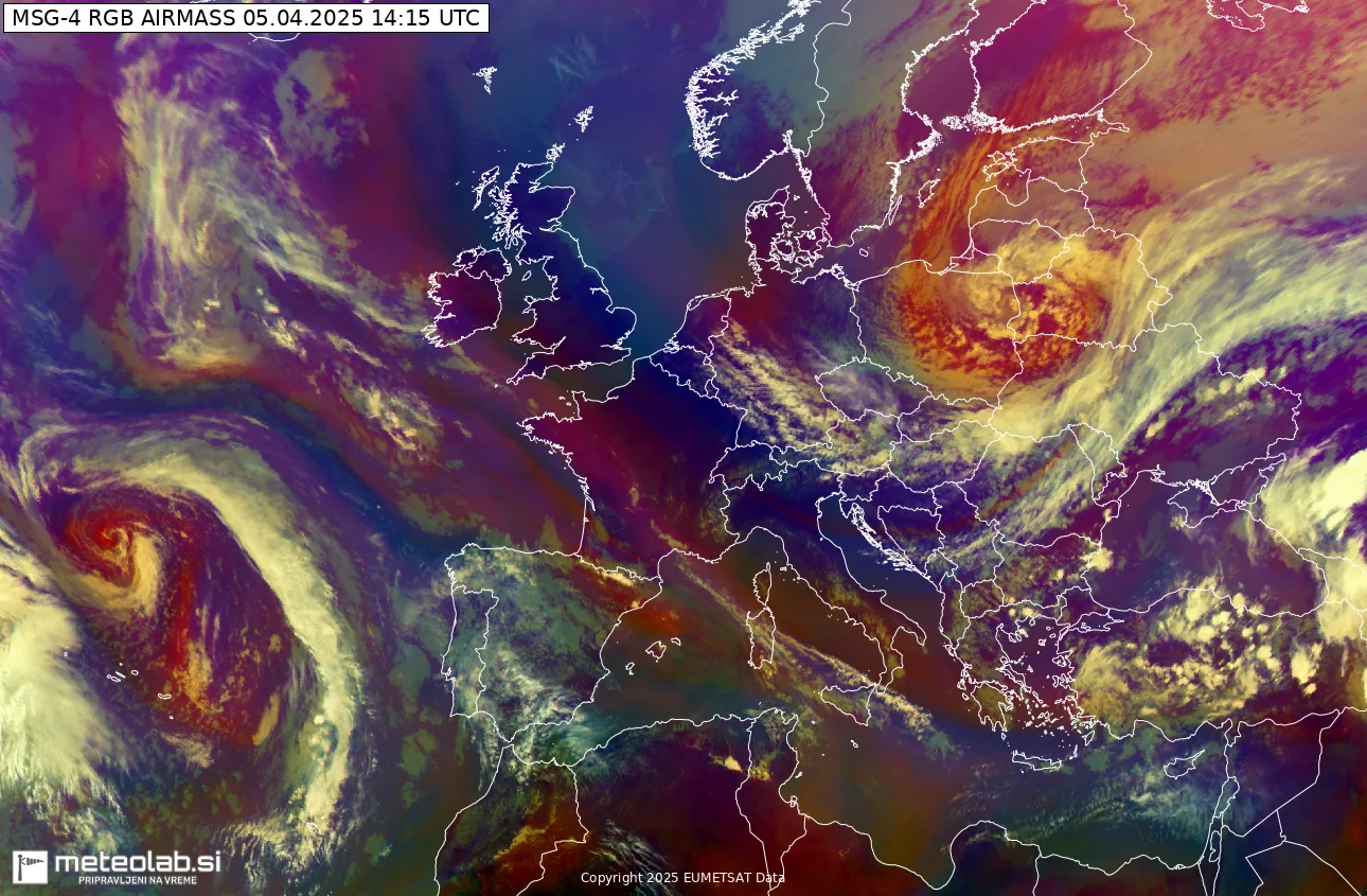
The progress of significantly lower temperatures is relatively rapid across the Baltic region and the eastern European plains, with temperatures in the single digits spread behind the Arctic front.
While still warm, spring weather was spread further south and west. It was 20 to 25 °C from the Balkans to France and the Mediterranean.
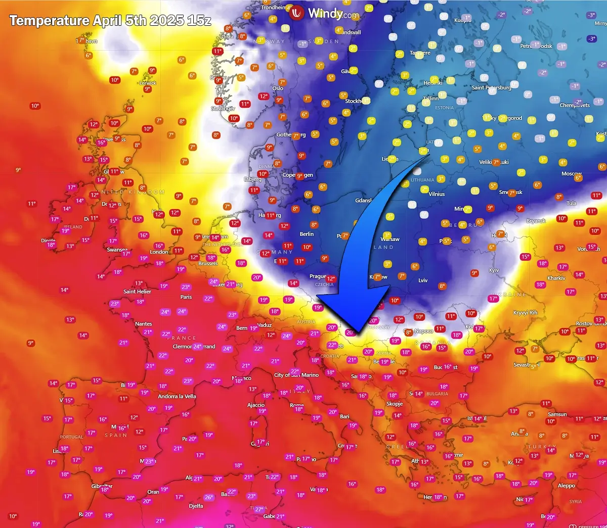
These temperatures will be dramatically flipped into much colder overnight and Sunday, with 15-20 °C colder than today by Sunday night and Monday morning. This will be combined with strong downslope Bora winds towards the Adriatic Sea.
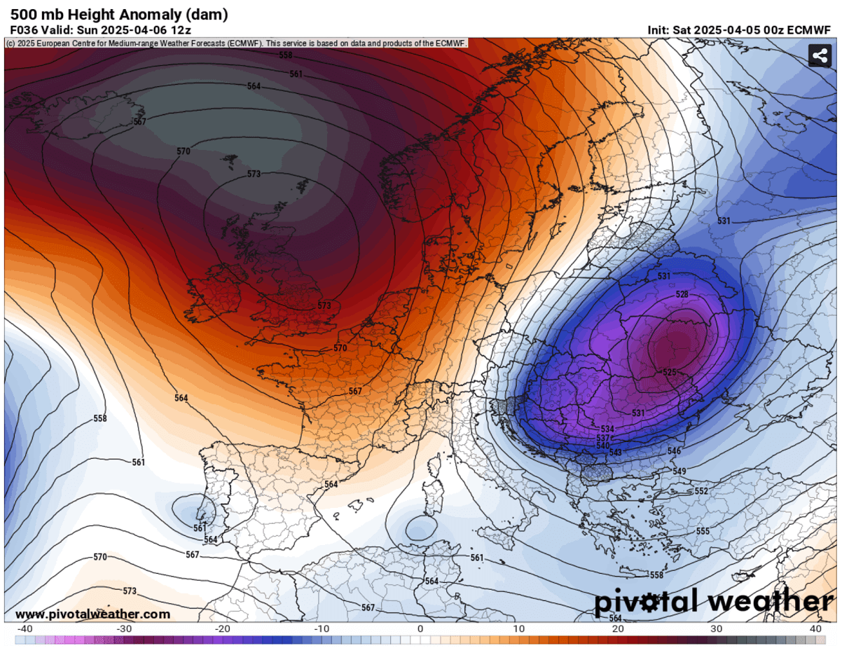
Polar Vortex remnants send a deep cold wave across Eastern Europe and the Balkans
So, the general weather picture over Europe and the Atlantic indicates a dipole pattern with an intense blocking High over the North Atlantic and western Europe, while a significant cold core is travelling across Eastern Europe.
This low will move across the Balkan peninsula on Monday, with another wave crossing by mid-week.
An overview of the surface pressure patterns reveals that a substantial surface high-pressure system is established in the west, while surface lows are located in the park over Ukraine. This introduces a strong northerly flow between these two large-scale systems, delivering much colder temperatures across Eastern Europe and the Balkans.
These systems are forecast to persist for a few days so that the cold pool will remain strong and deep until next weekend. However, it will remain confined to the eastern half of Europe only.
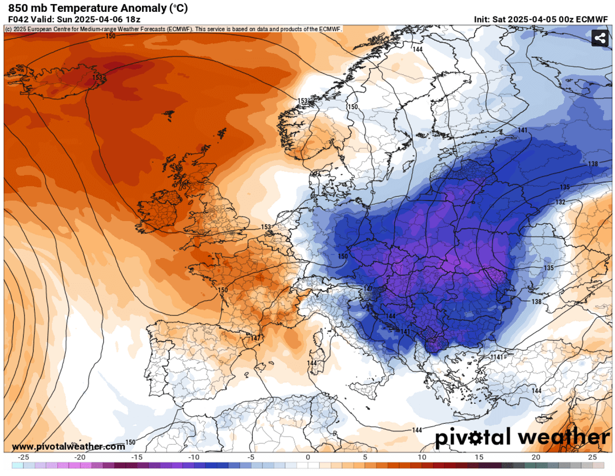
The 850mbar temperature anomaly indicates how significantly colder temperatures are forecast. The core of the Arctic cold pool will be roughly above Hungary, Romania, and Ukraine by Sunday night, gradually spreading south towards the Black Sea on Monday and Tuesday.
A 10-15 °C colder period for 2-3 days is forecast across Eastern Europe and the Balkan peninsula countries, delivering significant cold stress for the early vegetation and blooming trees.
It will remain above-normally warm in the west and over the North Atlantic, with a much above-average period over Iceland and Greenland.
A persistent cold pool locally delivers a lot of fresh snow
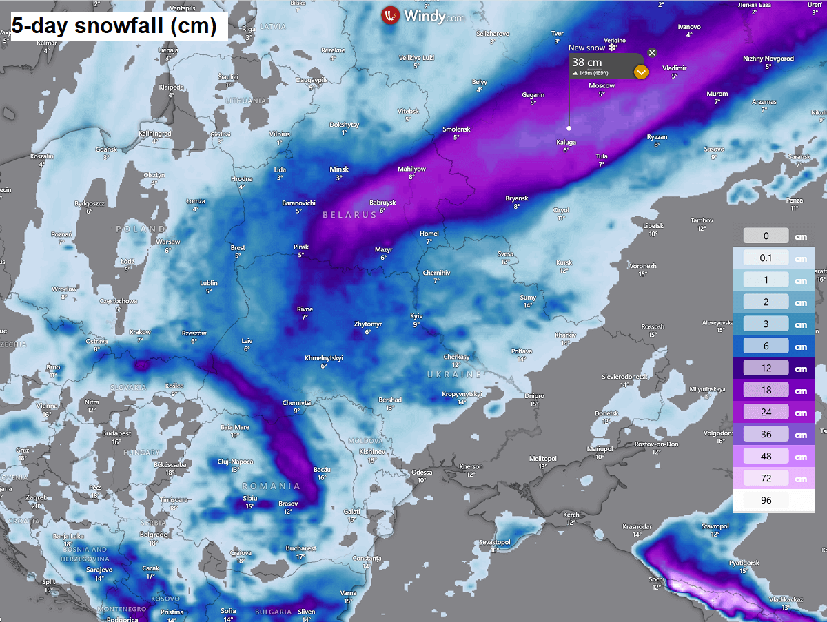
Along the first impact of the Arctic cold Saturday night into Sunday, a pronounced frontal system forms over Belarus, Ukraine, and western Russia.
This will result in heavy snowfall and strong winds, delivering blizzard conditions from blowing snow across southern Belarus eastward across Moscow, Russia.
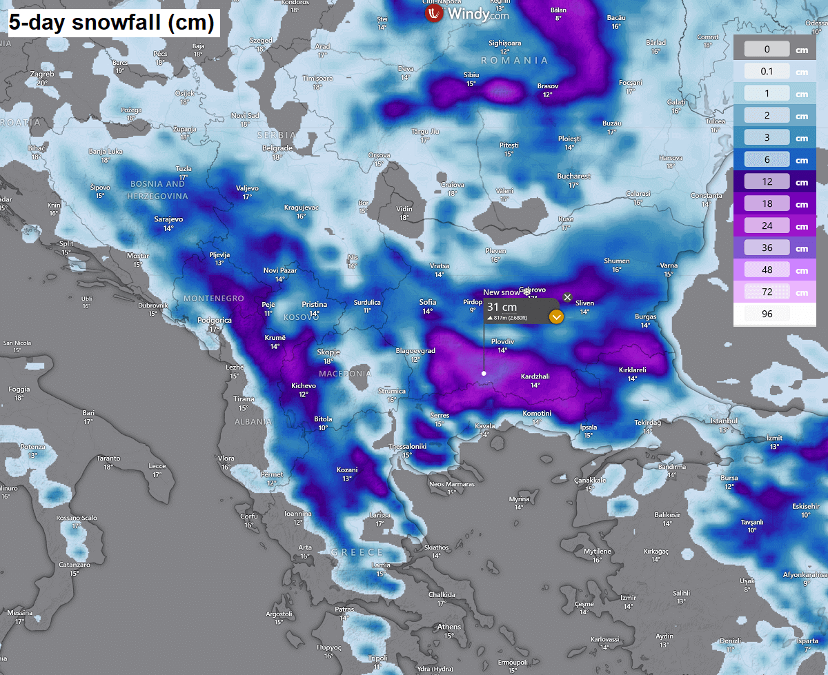
Once the cold pool and frontal system push across the Balkan peninsula, they will combine with higher moisture to reach the southern countries. There, snowfall will develop, resulting in decent amounts of fresh snow.
However, the highest amounts are forecast along the eastern and northern slopes of the mountain ranges across the southern Balkans, but lowlands may also experience some snow accumulation. Snow is forecast across Bosnia and Herzegovina, Montenegro, North Macedonia, northern Greece, Romania, and Bulgaria.
As mentioned, another wave is forecast to travel across eastern Europe by mid-week and blast across the Black Sea into Turkey. Therefore, this will introduce heavy snowfall for the region with a locally significant amount of fresh snow.
Some areas could receive even more than 50cm of snow from Thursday through Saturday next weekend, especially in northeast Turkey, where the Black Sea effect snowfall is likely to develop, thanks to the cold air mass blowing across the sea.
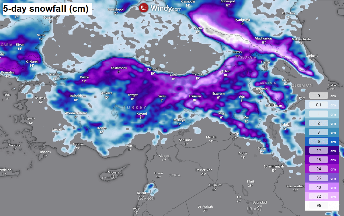
A lot of snow is also forecast across the Caucasus mountain range, with around 100 cm fresh locally by the following weekend.
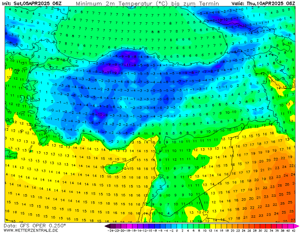
High risk for damaging morning frosts across many countries from Monday through Thursday
The pattern established over Europe this coming week will allow the sizeable cold pool to persist for a more extended period, most likely from Sunday this weekend into Saturday next weekend. The following chart represents the 5-day temperature anomaly until Friday.
Eastern Europe, the Balkans, part of central Europe, and southern Italy, including Greece and Turkey, will remain in cold weather, significantly below normal for early April.
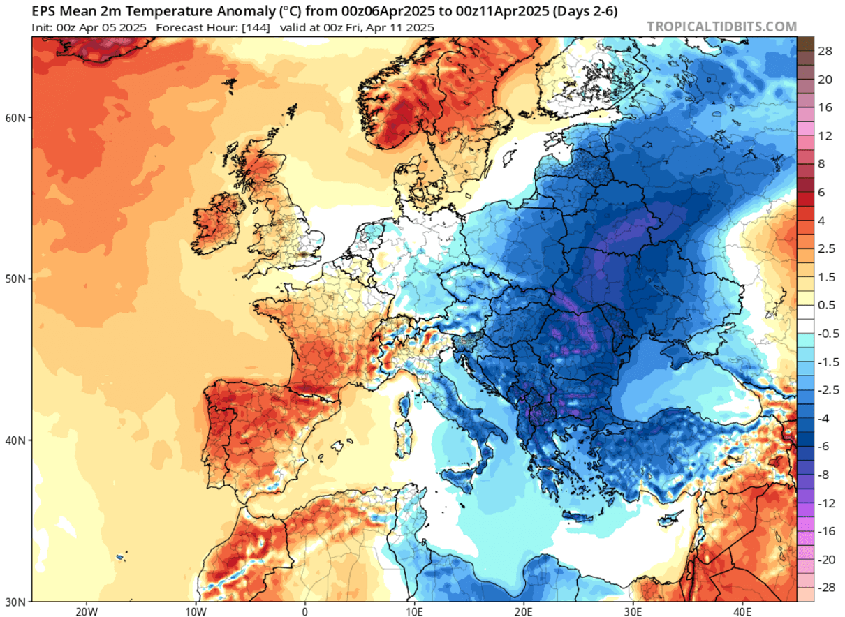
This will result in a pretty cold, frosty morning for many countries. The most critical conditions will likely be over the Balkan peninsula, where nature’s vegetation is already in full swing after the recent warmer periods.
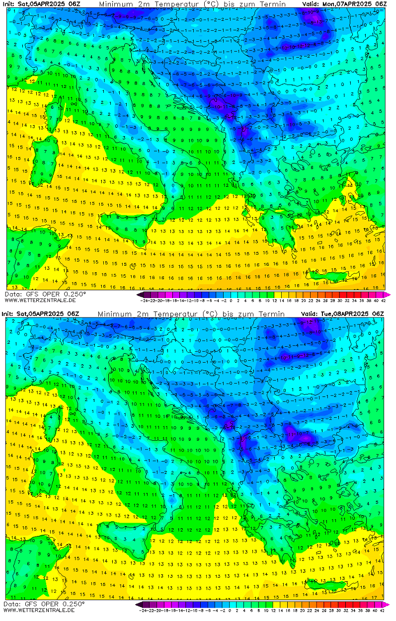
These are morning temperatures for Monday and Tuesday, both showing many areas in deep freeze. Thus, it is hazardous for blooming fruit trees, including vineyards. Some areas could see morning temperatures around -5 °C, typically leading to catastrophic vegetation damage.
Cold temperatures below freezing are also possible in inner Italy on both days.
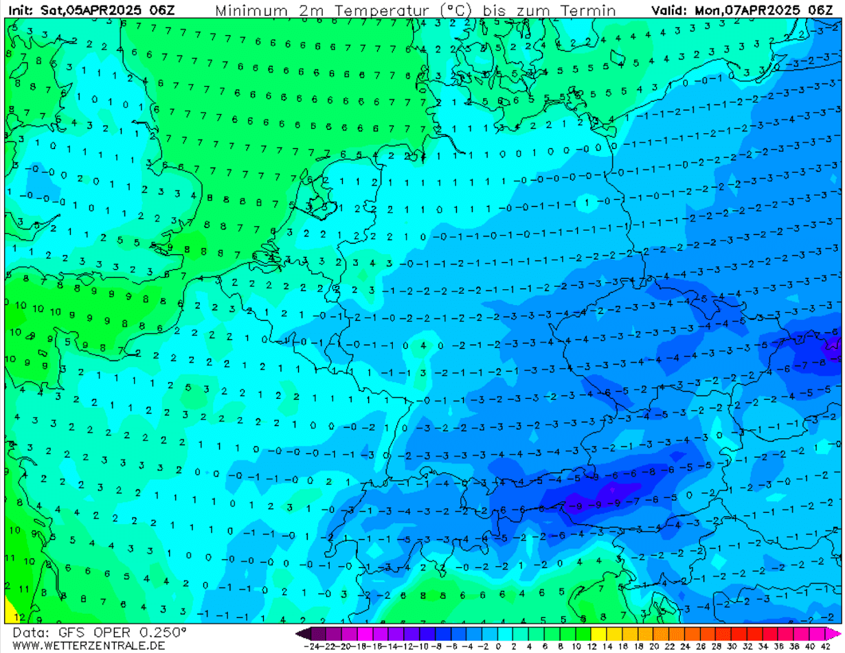
Although the significant cold pool will remain centered over eastern Europe and the Balkans, temperatures will also be pretty low in central Europe. Monday morning is especially critical.
Freezing temperatures a few degrees below °C are forecast across south-central Germany, Austria, Slovenia, eastern France, Czechia, and Slovakia. This could significantly damage blooming fruit trees.
Conditions will gradually improve by mid-week, but temperatures will remain near freezing until Thursday.
Following the second wave on Thursday and fresh snow into Turkey, temperatures are also forecast to dip far below freezing. On Thursday, many areas could see morning temperatures critically low, from -5 to -10 °C across west-central Turkey.
Stay weather aware regarding the potential frosty impacts over the coming days.
Wxcharts, Windy, Climatebook, TropicalTidbits, and Pivotalweather provided images used in this article.